
I often look at Google Maps to find new places to ride. Some of the roads look fascinating going through some beautiful country. The problem is a lot of them don’t exist.
Mistake Road is a classic example. Driving along Dunlop Lane in Kurwongbah, if you read the Google Map, you’d expect a nice ride through to Shea Road. But the bitumen gives way to gravel, which gives way to dirt and mud, and in the end, all that is left is a horse trail.
And off that horse trail is Mistake Road.
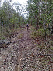
So Steve and I based through some bush on the bikes, down Mistake Road.It went through a creek that was knee deep, so I cunningly took off my shoes and socks to keep them dry and waded through, holding up the bike.
The next creek, Steve said “Ride through it, it’s easy” so I did, stalled mid-way and soaked my lovely dry shoes.
At this point the track disappeared and we found ourselves in a paddock near a farm house.
“Woops, we’re accidentally trespassing” I thought. And just as we were about to get out onto the main road, we met up with the land owner driving her car out.
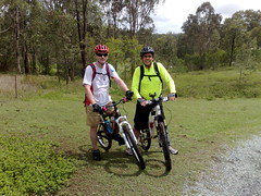
I had my speil all worked out “I’m really sorry. We’re lost, can you tell us how to get out of here?”. But before I could, she congratulated us telling us that they’d only just prepared a new horse riding trail through their property, and we were the first people to come along it on our bikes.
Wendy was really friendly, and I was relieved that we hadn’t antagonized some old hermit of a farmer who was going to set (in my imagination) hungry dobermans onto us.
But the point is that there are hundreds of old roads that are on maps, that “aren’t really there”. But if you ride down them on a bike, just at the point where they “disappear” you can bash through the bush and find horse trails that are probably more than a century old.
I’ve got a hunch that the “Old North Road” from Brisbane to Durrundur came through here somewhere.
Constance Campbell Petrie writes about a Indian fellow by the name of Shake Brown kidnapped an Aboriginal woman and sailed to what is now Noosa Heads. After he’d had enough of roughing it, he came down the Old North Road on his way back to Brisbane, where he was met by some Aborigies who exacted revenge from Brown and killed him on the banks of what is now Browns Creek.
Browns Creek runs through this area, as you can see on the map, so it’s very likely we rode today near where Shake Brown was killed, which is also where the Archer Brothers would have ridden their horses in the 1840’s on the way to Durrundur Station near present day Woodford.
So next time you drive your car to the end of road that really ought to be there according to the map, remember that the road probably still is there – you just need a good horse (or a mountain bike) to go any furhter.
No comments:
Post a Comment