
If you follow the Brisbane River upstream as far as you can go, it eventually splits in two branches. Our adventure today took us in a big loop through through the most upper reaches of the Brisbane River, along its Eastern and Western Branches.


We started our adventure at the confluence of the Eastern and Western Branches of the River. This is where the Brisbane River officially starts.
Eric and I had ridden through here a while ago on our way from Nanango to Jimna, and had both wanted to return.


As we were all preparing to ride off, local farmer Phil Lord from Mount Stanley Station said “G’day” while dropping off some feed for his cattle.
We rode off along Eastern Branch Road, over numerous cattle grids, past one or two farm houses into the dry brown hills that form the source of the Eastern Branch of the River. As we passed the sign I think we all secretly hoped that there would be no pig shooting during our visit.

The area is in the grip of drought, the paddocks are brown, the ground is dusty, and the river has dried up into a series of disjointed ponds.

Occasionally we’d come across an oasis in the dry river bed bustling with thirsty birdlife and the occasional deer.

Even in its dessicated thirsty state, this is still spectacular country.


The morning air was still cool, and we enjoyed the leisurely roll through the undulating hills, counting the creek crossings and wondering how many we’d pass before we began climbing into the hills.
After about an hour we pulled up under a couple of shady trees and had a quick break. The steep hillside in the distance was crisscrossed wtih the tracks of hungry cattle scouring the bare slopes for the odd blade of grass.

Shortly before “The Big Climb” we met Phil as he checked his cattle. He kindly asked if we had enough water (we did), then left us to take on the steep ascent up Wombi Creek Road.

We left the dry bed of the Eastern Branch and pointed our bikes up the hill. With the dessicated gully of Wombi Creek dropping to our left, we slowly toiled upwards.

The slope was rideable for most of the way, but the loose rocks and gravel made it impossible to pedal in parts.

Unlike the easy roll along undulating river flats, the climb up a big hill is often a solitary experience. Everyone conquers the climb at their own pace.

But its always a relief to finally reach the top and cool off in the shade.

The hoop pine plantations near Mount Gibbarnee stretch forever northwards. We followed some forestry tracks along the top of the mountain for a while.


Eventually we began the major down-hill leg of the journey.
Long descents are usually a lot of fun. Today we had the double challenge of dry lantana sticks poking out from the side of the trail, and large “baby head” rocks on the track. We had to take this drop carefully.
On the way down, Clare and Anna gave us a demonstration of “Bush Yoga” at one of the more scenic spots.


I lacked their natural elegance when I attempted it.

We continued our steep descent to the Western Branch, sliding over loose stones, flying over drop-offs, and enjoying the cool breeze.


A barbed-wire gate marked our arrival at the Western Branch of the River. They’re sometimes tricky to open, but Eric deftly unhinged it, and let us pass through.
And so we started the long count-down of river crossings. The Western Branch of the Brisbane River would cross our path 31 times before we finished the ride. Riding here would not be a good idea after much rain.

The thirsty river had dried up and left a chain of shrinking ponds. We stopped for lunch in the shade by a one of the remaining small lagoons.


“I wonder why this is called The Stony Pinch?” I pondered out aloud, as I worked the pedals up this stony pinch climb.
This Goanaa stood motionless clinging to the trunk of a tree. He was a magnificent two metres in length and proudly eyed us as we admired him.

The wildlife must have decided it was time to say “G’day”. This eagle soared overhead as we pedalled along. I pointed the camera above my head and furtively clicked a few hopeful shots as I continued riding.

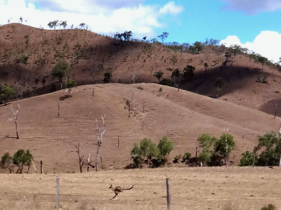
Not to be outdone by his flying friend, this Kangaroo chased us for a while…
…and a few friendly horses gallopped nobly past.


The river crossings became more frequent (and wetter) as we continued down stream.


I think this huge boulder by the side of the road was irresistible to Clare, who practiced a bit more “Bush Yoga”.
I decided not to copy her this time.


We eventually rolled back to our starting point at the end of Western Branch Road. The 50km loop had taken us about four and a half hours including breaks. We climbed about 1,000m in vertical ascent, and I burned about 2,500 kcal and used up about three and a half litres of water.
This is a spectacular ride. It would be stunning when the rivers are flowing. I’d love to return then.
This ride rates 8 out of 10 on the tough-o-meter. Take plenty of water, and some climbing legs for the big hill.
Thanks Clare, Kat, Anna, Eric, Darb and Paul for another memorable ride!


No comments:
Post a Comment