Please note: you can find a more up to date version of this blog at http://blog.neilennis.com

Friday, November 16, 2012

Eclipse – 2012

Read More

Totality


After experiencing the Eclipse of 2002 in Woomera, South Australia with my daughter Laura, I was hooked. I vowed I was definitely going to do my best to see this rare event a second time. So ten years later, Liz and I agreed to take the kids to North Queensland to catch a glimpse of one of nature’s most awe-inspiring spectacles.


There were differences between the two events. Woomera is in the desert of South Australia. So in 2002 we had an almost certain chance of cloud-free skies. The down-side was it was miles from nowhere, we had to camp out in the desert, and that eclipse only lasted 30 seconds.


Vila Paradiso - Palm Cove

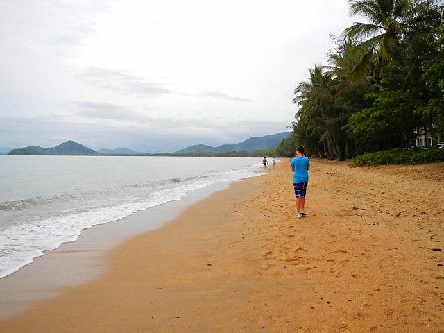
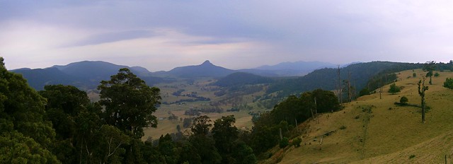
Roll forward to 2012. Palm Cove is in tropical North Queensland. November is the start of the “Wet Season” where it rains incessantly for 4 months or more. There was a pretty big chance that clouds would foil our attempt of viewing the eclipse. The up-side was that Palm Cove is a beautiful resort town on the beach. We were able to book great accommodation across the road from the beach, with uninterrupted views of the morning sky. And this Eclipse would last over two minutes – four times longer than the previous one.


The Beach to Ourselves

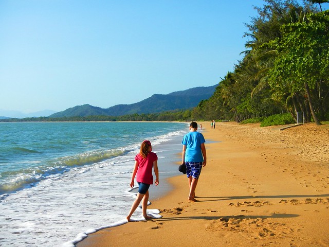
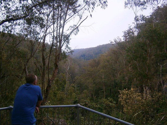
We arrived at Palm Cove a few days before the main event. We had the beaches to ourselves. Although you could spot the odd geeky looking tourist in town (do I look geeky), this tropical paradise was serene.


Waiting for Totality

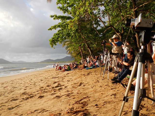
A couple of days later it was packed. Umbraphiles (look it up) as far as the eye could see. There were network TV cameras on the esplanade, high-powered telescopes, satelite dishes, and learned looking people with devices I didn’t have a clue about. We just grabbed a couple of beach towels, walked across the road from the hotel, and plonked ourselves down on the sand to wait for the main event.


Putting on the Eclipse GlassesWatching the Eclipse

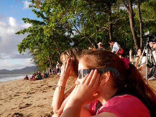
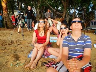
We all had our Eclipse Glasses – I had bought them on eBay over six months ago. I gave them to Liz, because she was less likely to lose them than me :) Nevertheless, before the trip I think I asked her half a dozen times if she had packed the glasses. (I just wanted to make sure).


Clouds Before the Eclipse

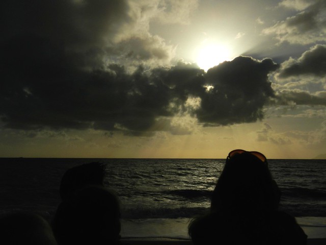
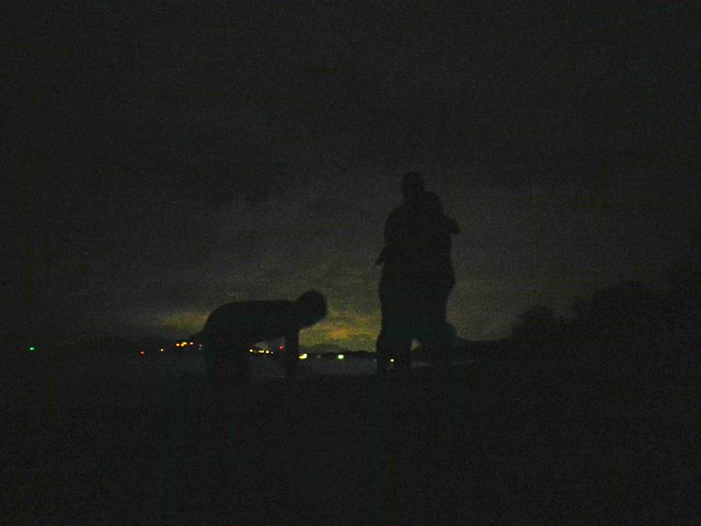
And then disaster struck. The clouds started massing on the eastern horizon like they do most mornings at this time of year. The sun disappeared and two thousand people sat on the beach crossing their fingers and willing the clouds to part.


The Clouds Part

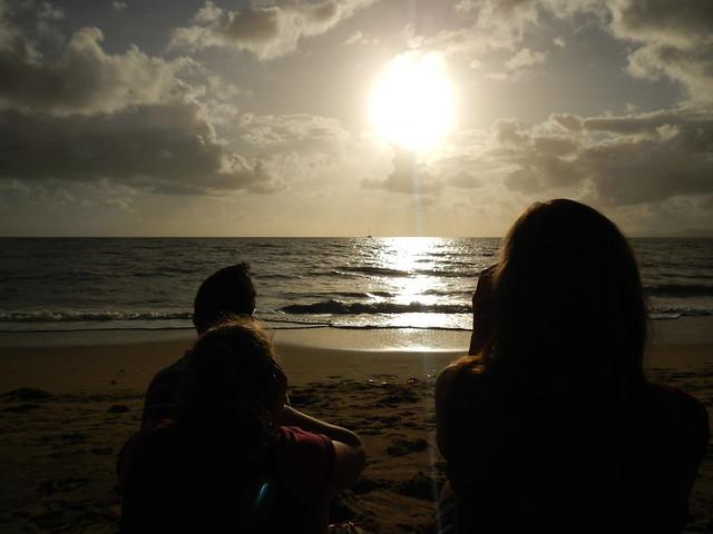
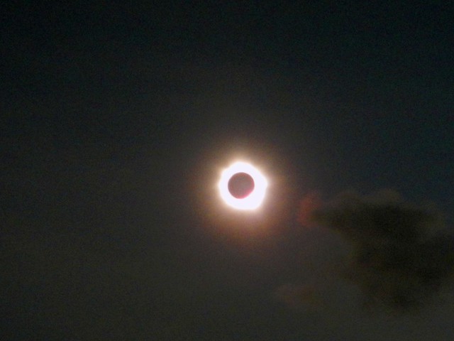
And they did! People cheered. I got a bit teary because I finally realized this was going to happen! We were going to see the eclipse. I had my watch synchronized to the second and counted off the minutes, the seconds to totality.


Totality

Totality


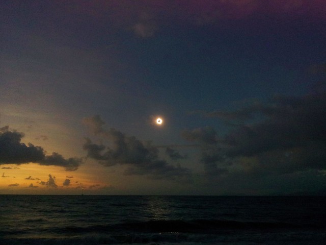
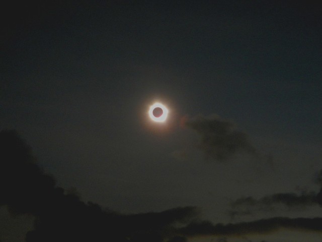
And then “It” happened. Have you ever heard several thousand people gasp in awe? I was ecstatic. “You can take your glasses off now” I said to the kids. “Oh Wow! Look at that!”. The sky went dark, the stars came out. And a fiery black hole appeared in the sky where the sun was a few seconds ago. And I could look straight at it. And, emotional petal that I am, I cried. People cheered, yelled, sighed, and just gazed at something simply beautiful.


And as you can see, I did manage to find a few seconds to take a couple of photos. The professionals got some amazing photos, but the images I came for were those that are now in my head. I’ll never forget what I saw, and how I felt.


And, I think I’m now an eclipse chaser. I’ve spent just over two and a half minutes of the last ten years in “Totality”.


I want more :)


Sunday, November 11, 2012

Palm Cove

Read More

Palm Cove


There’s a total eclipse of the sun in North Queensland on 14 November, so I brought the family up here to enjoy it. (Stay tuned for pictures in a few days). A lot of people are just flying in, then flying out, but we thought we’d stay the week and do the “tropical tourist” thing.


We’re staying at Palm Cove, half way between Cairns and Port Douglas. It happens to be very close to the centre line of the eclipse, so provided the weather holds out, we should have an ideal opportunity to witness over two minutes of totality.

Palm CovePalm Cove

I wanted to do a bit of mountain biking while I was here, and didn’t want to have to pack my bike and lug it up here, so I spoke with Tor at PD Bike Works who did me a really good deal for the week on a nice GT hard tail.


My first ride for the trip was to the mountain bike trails at Smithfield about 10km south of Palm Cove heading back towards Cairns.


John

I had arranged to meet another rider at Smithfield, but he didn’t show up at the last minute. It wasn’t a problem though, as by chance I bumped into John who offered to take me on a tour around some of the tracks around Smithfield.

Trail map

If you don’t have anyone to show you around, there’s a high quality map at the trail head. It’s easy to take a photo of it with your phone, so if you get lost you at least have a map to give you an idea of the layout of the tracks.


A couple of minutes after leaving the trail head, John too me past a dirt jump area containing a large jump called “The Bowl”. Crazy riders shoot down a long run, plummet into the Bowl and see how high they can jump up the other side. There’s a 5m high pole to make it easier to measure the height of the jump. Personally I wouldn’t even need a tenth of that, so whoever does these jumps must be pretty hard-core.


We slowly made our way up to the high point of the ride along a trail named “Cadels”. It’s named after Tour de France champion Cadel Evans who came here as a 19 year old, and rode the trail, and by all accounts nailed it. We then dropped down a gnarly descent called “Jacobs Ladder” – steep, rocky, slippery and a lot of fun.

Beware

One of the hazards of riding in the tropics is a particularly nast plant called the Gympie-Gympie Bush. It is so toxic, contact with it can cause sever debilitating pain, vomiting and even death in some circumstances. So there are lots of signs around the trails warning riders to give the bushes a wide berth.


Smithfield Trails

Much of the park winds through some beautiful rainforest including this track called “Back Snake” which snakes through the rainforest, over some fun jumps and through a couple of creek crossings.


Kangaroos, Smithfield

After saying good bye to John, I made my way back to Palm Cove via some trails behind the university, avoiding the main road. On the way back I was impressed by this field full of kangaroos happily grazing beside the road. They didn’t seem to mind me pestering them with my camera.

The Beach at Night

Back at Palm Cove, what day at the beach would be complete without a family walk along the beach at night?


32km in just over two hours with about 200m of vertical ascent. The Smithfield part of this ride would be a fun outing for anyone who loves mountain biking. The tracks are varied, fun, well marked, and beautifully maintained. If you’re riding there from the north, try to keep to the bike tracks as the roads can be quite busy. I’ll give this one 6 out of 10 on the tough-o-meter.


Sunday, November 04, 2012

Goomburra

Read More


Goomburra is part of the “Main Range National Park” on the Great Dividing Range in South East Queensland. The Goomburra section of the park is located north of Cunninghams Gap either side of Dalrymple Creek. It’s named after the Gooneburra aboriginal people. In the Keinjan language, “Gooneburra” means “Fire people” from the tribe’s habit of setting fire to grasslands as a means of managing the land. Professor Maurice French, at the University of Southern Queensland, says that they numbered perhaps 1500 to 2000 people.


Dalrymple Creek is named after Ernest Dalryple, a European squatter, who arrived in the area in 1841 to take up a “selection” on what the settlers called “Goomburra Run”.

GoomburraFig Tree - Main Range National Park

Eric, Tony and I started our ride from “Gordon Country” in the valley along Dalrymple Creek, and then slowly wound our way up the long slow climb into the rainforest. It took about an hour to reach the top, and I was glad to finally get there.

Mount Castle Lookout, Goomburra

The views from Mount Castle Lookout were amazing. Mount Castle and the surrounding peaks of the Liverpool Range form a sharp ridgeline extending from the Main Range north-eastwards towards Laidley. I was impressed by the cliffs and the views off in the distant east of the Teviot Range and Lamington Plateau.


At Mount Castle Lookout, the Great Dividing Range splits in two branches. The main range heads off to the west while “The Mistake Mountains” go off to the north. They were called this because in the early days, people mistook them for the main range. We rode north over The Mistake Mountains to “The Winder”. Years ago, loggers converted an old truck into a winch to haul up the large logs from the steep slopes of these mountains. The loggers have gone, and all that is left of the “Winder” are these rusty ruins.


Eric took what he called a “Micro nap”. He’s a lot faster on the bike than I am, so I suppose he decided to make the most of the time that he spent waiting for me to catch up :)

Tree Fern - Main Range National Park

The ridge line along the Mistake Mountains is covered in rainforest. These Giant Tree Ferns (Cyathea australis) were all over the place. I’ve read somewhere that they can group up to 20 metres in height. This one made my bike look like a toy.


Fire Management Trail

Once we’d finished at the Winder, we had to climb back the way we had come regaining 250 metres in altitude, back to the junction with the Main Range. We then continued our journey westwards along the Main Range.

Glen Rock National Park

Glen Rock National ParkGlen Rock National Park

The views along the track were spectacular. Every few minutes we stopped to catch glimpses of the valley through the trees as we looked down into “Glen Rock” park below.

Enjoying the view

As we rode further along the track, the slopes on either side became progressively steeper. Eventually, it felt like we were riding on the top of a razor blade. On our left, steep slopes dropped down to Dalrymple creek to the south. On our right, sheer cliffs dropped down to Glen Rock Park to the north. The track was wide, and safe, but it meant we had some amazing views.


I couldn’t belive the beauty of the landscape we were looking at.

Glen Rock National Park

As I looked down into the valley in Glen Rock National Park, I thought that perhaps we should come back to this place in the not too distant future and do a bit more exploring. There is some stunning country in South-East Queensland. With a reasonable amount of fitness, and a decent mountain bike, a whole new world opens up to explore. More than enough for one life time. In the last three yeas I’ve seen more natural beauty in thiis part of the world by riding my bike than at any other time in my life.


From our mountain-top high we rolled back down the mountain to “Gordon Country” 4wd park. There are a number of tracks down the mountain – some precariously steep, some rather gentle. By luck we managed to pick a quick but safe descent which had us back at the car in about 10 minutes.


All up we cycled 37km in about 5 hours including stops, climbing a total of 1,400m in vertical ascent. I burned about 4,000 kcal. This is probably the toughest sub 40km ride I’ve done. We had to push the bikes up a couple of hills, and had to work hard on some of the longer climbs.


I rate this one 9 out of 10 on the tough-o-meter. You won’t need more than intermediate mountain biking skills – the tracks aren’t too technical except for one or two steep descents. But you’ll need moderate to high fitness, plenty of water and snacks. Make sure you take a camera :)


Sunday, October 28, 2012

Condamine Gorge

Read More

Condamine Gorge

“The Head” is a spectacular spot up in the Great Dividing Range of South East Queensland, near the border. It gets that name from the fact that it forms the headwaters of the Condamine River and the Murrary Darling Basin. Starting as a trickle on the slopes of Mount Superbus, it flows through Condamine Gorge joinng up with the Balonne River, the Darling River and eventually the Murray River before draining into the Great Australian Bight near Adelaide in South Australia.


Today we were lucky enough to ride through some of this beautiful country in a loop from the small town of Legume, in Northern NSW up into Acacia Plateau, then along the Border Fence to “Head Gate” and back to our starting point via Condamine Gorge (also known as Cambanoora Gorge).


The traditional Aboriginal owners of this area are the Githubal, Kambuwal and Jocumwal people.

Acacia Plateau

For the first hour of our journey we took a long slow climb up onto Acacia Plateau, while we battled swarms of flies. Thankfully Eric had the foresight to pack some insect repellant which kept the pesky insects away from our faces, allowing us to enjoy to majestic open blue-gum forest.

The Border Track

The Border TrackThe Border Track

The rocky road eventually rises up to the “Border Track” following the rabbit-proof fence along the border between Queensland and New South Wales. At an altitude of over 1,000 meters, this section has thick rainforest on the NSW side of the fence and open farmland on the Qld side. I’ve seen similar scenarios at other places along the border (such as The Border Ranges) and it makes me wonder about the relative priorities of both states in their early years, and the importance of land-clearing to Queensland in the 19th and early 20th centuries.

Trough Creek

From the border track we dropped about 600 metres in altitude in the space of 8km. I don’t have any pictures of it since I was clinging on to my handlebars for dear life while I bounced down a rocky track, dodging stray logs and precarious ruts. The Trough Creek descent is a mountain bikers delight, but it’s rough. You need good suspension, and a reliable wheel / tyre combination. I suspect riding this on a cheap bike would result in pinch-flats and crashes.


I got to the bottom yelling out “Wow, that was awesome!”

Koreelah Creek

Koreelah Creek

A few minutes later, after bouncing down some more rocky roads, we eventually reached the rock pools at Koreelah Creek, where we stopped for lunch.

White SwampWhite Swamp

“White Swamp” marked the lowest elevation point of the ride. From here we faced another long slow climb up to “Head Gate” – the Qld / NSW border crossing.

Head Gate

Rabbit Fence

“Head Gate” is a secluded border crossing in the middle of nowhere. It boasts a dilapidaed house, and a shed. If you stand in NSW and look north to Qld, a huge sign tells you how un-welcome rabbits are. In fact, if you try to keep rabbits in Qld, you’re liable for a $30,000 fine. If you stand in Qld and look south, you’ll see a similar huge sign wich tells you you’re not allowed to take livestock into the state along that road.


For us it was a welcome place for a short break. It was also a reminder that we had stopped our long climb and could look forward to some more descending.


Condamine Gorge

As we rode along Condamine River Road, we enjoyed some amazing views of the Gorge.

Condamine Gorge

Like the sign says, if you go along Condamine River Road you need to be prepared to cross the river 14 times. And they’re not just shallow little crossings, they’re deep, and you’re definitely going to get wet.

River Crossing Condamine Gorge

We rode through several crossings. Eric showed us how it was done. We waded through the rest of the crossings, carrying our bikes. Normally I hate getting my feet wet. On this trip, I just accepted the fact that it was going to happen, and didn’t worry about it. I actually discovered that it’s not that bad riding in wet feet – provided it happens towards the END of the journey and not the start :)

Crossing the Border

Once we got to the end of Condamine River Road, we headed south along the bitumen, across the border again, and back to our starting point at Legume.

Queen Mary Falls

Queen Mary FallsQueen Mary Falls Lookout


Our route took us in a big circle, in the middle of which was Queen Mary Falls. Since we didn’t actually ride to that point, we decided to drop by in the car on the way home. The falls are only a five minute walk from the car park on Spring Creek Road, so it was worth the detour.

Carrs Lookout,

We also stopped at Carrs Lookout where we were gobsmacked by the views of Mount Superbus and Wilsons Peak.


What a stunning way to finish the day.


All up we rode about 64km in 6 hours including breaks. We ascended 1,450m and I burned 3,700 kcal. The ride has two tough climbs, one sketchy descent and numerous river crossings. It also involves a three-hour each way drive from Brisbane. I’m giving it 9 out of 10 on the tough-o-meter. You need medium to high fitness, medium skills, a good bike, and some good riding buddies. Be careful after rain as the river crossings may be impossible to ford – which means a long detour. Take lots of water in Summer – it is hot work. Take lots of snacks.