Please note: you can find a more up to date version of this blog at http://blog.neilennis.com

Saturday, February 13, 2010

Drapers Crossing & Bunya Cemetery

Read More

Draper's Crossing, South Pine RiverDraper's Crossing, South Pine RiverDraper's Crossing, South Pine RiverDraper's Crossing, South Pine RiverDraper's Crossing, South Pine River

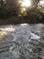
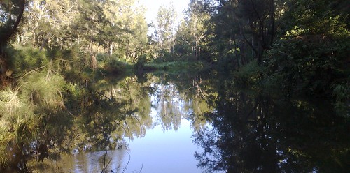
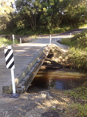
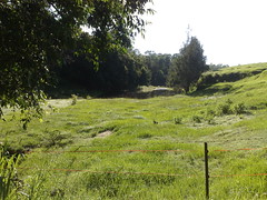
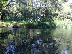
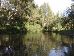
On my cycle back from Samford this morning, I thought I’d take a detour over Drapers Crossing that crosses the South Pine River through some idyllic dairy farmland.


The rickety bridge looks like it’s been there for ages, but the actual crossing has been in use much longer.


At 28 years of age, Jacob Draper an English migrant, built a slab cottage near here in 1869.


His land holdings grew, and his family eventually established a successful dairy farm. The family continued to operate successful dairy farms until well into the 20th century.


(Source “Pioneering The Pine. A Short History of the Pine Rivers Shire” by Leith Barter)


Bunya CemeteryBrothers

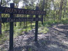
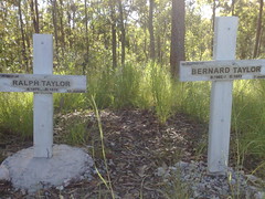
A sad reminder of the heartbreak faced by pioneering families in the district in the 1870’s. Bernard died aged 7 months. Half a year later, his twin, Ralph, died.


The twin boys must have been one of the first burials in the Bunya Cemetery, which was established in 1873.


View Larger Map


Friday, February 12, 2010

Bunya Crossing

Read More

Bunya Crossing, South Pine RiverBunya Crossing, South Pine RiverBunya Crossing, South Pine RiverBunya Crossing, South Pine River

I enjoyed cycling over “Bunya Crossing” this morning, and riding along the banks of the South Pine River.


Recent rain has given the river a generous flow, and I passed several spots which looked like they would be great for a swim.


“Bunya Crossing” crosses the South Pine River between Eaton’s Hill and Albany Creek.


This area was originally settled by James Cash around 1851. He gained freehold title in 1858, becoming the first freehold land owner in the district.


You can hike or cycle this area starting at Sargeant Reserve on Bunya Crossing Road, cross the river, and follow it mostly by pathways all the way down to the main bridge on South Pine Road at Cash’s Crossing.


View Larger Map


Saturday, February 06, 2010

Sunrise Cycle around Pine Rivers

Read More


Our family is lucky to live in such a beautiful place.


Here’s a video I took with a mobile phone of one of my bicycle rides around the local area. I strapped my Nokia 95 to my handle bars, pressed the “record” button and started riding. It’s a bit shaky, and you can hear some heavy breathing when I ride up Grant Street, but it’s always a pleasant ride, and a great way to start the day.


Pine Rivers has some spectacular scenery along with some amazing history. The Hoop and Bunya Pines are gorgeous, the Lakes look fantastic, the D’Aguilar Range in the background is impressive. I’ve only just started to appreciate all of this, and highlights to me that if we’re not mindful, we can spend our time in wonderful places and often never see or appreciate the splendour that is staring us in the face.


So I tell everyone who’ll listen – get on a bike and have a look around the place where you live. Ask questions, find out about your local history. You’ll be pleasantly surprised!


View Larger Map


Friday, February 05, 2010

Giant Eucalypt

Read More

I saw this giant eucalypt while cycling around Mount Glorious last week.


Mist and rain were swirling around on the mountain top. It was spectacular, and worth the 80km return trip and 1500m total ascent.


Mount Glorious is part of the D’Aguilar Range national park, and has some spectacular forests.


Unfortunately the rain got in my phone so I wasn’t able to take any more photos.


View Larger Map


Tuesday, January 26, 2010

Deception Bay

Read More

Deception Bay

I thought I’d ride out to Deception Bay this morning. To make it interesting I cut through North Lakes, and found a couple of dirt tracks at end of Discovery Drive, North Lakes, which helped me get there from the South-West without having to navigate some of the major roads in the area.


It’s Australia Day today and at the waterfront, all the BBQ’s and picnic tables were taken – even at 9am. I’m not surprised because it’s very pretty, with great views to Scarborough, Moreton Island and Bribie Island.


Deception Bay was initially named Pumicestone River” by John Oxley in 1823. When he realized it wasn’t actually a river, he named it “Deception Bay” instead.


Poor John Oxley had more than his share of “deception” in this area – being led up the North Pine River by shipwrecked convicts Finnegan and Pamphlett, who told him it was the Brisbane River. When he realized it wasn’t the Brisbane River, he named it “Deception River”, but “North Pine” river eventually stuck because of all of the Hoop Pines that grew along the river’s banks.

Deception BayDeception Bay


Dr Joseph Bancroft was doctor and scientist who settled in the Deception Bay area in the 1860’s.


He is famous for his studies in parasitology, but one of the more touching memorials in the area is “Mrs Bancroft’s Bath”.


His wife was diagnosed with an illness which doctors suggested could be mitigated by bathing in salt water. To make this easier for Mrs Bancroft, Joseph had a bath carved out of one of the large rocks on the foreshore. At high tide, the water would fill the bath, and Mrs Bancroft would be able to take her saltwater bath with ease.


As you can see from the picture, the bath is still there as a testimony to one man’s love and care for his ill wife.

Mrs Bancroft's BathMrs Bancroft's BathJoseph Bancroft


View Larger Map


Monday, January 25, 2010

Mount Coolum

Read More


Mount Coolum


Originally uploaded by MagicTyger


Mount Coolum was a good climb. It’s not as high as nearby Mount Ninderry, but it’s a more challenging climb because there’s more slippery rocks to negotiate.


I rode the bike down from Coolum Beach, chained it to a tree in the car park, and climbed from there.


There are spectacular views in all directions, but it’s not as panoramic as Emu Mountain. You need to move around the summit a bit to see in different directions.


Nevertheless, it’s quite high, and very close to the coast, so it’s worth having a look.


The track was quite busy. I passed about a dozen people when I climbed.


Mount CoolumMount CoolumMount CoolumMount CoolumMount CoolumMount Coolum


View Larger Map


Emu Mountain Again

Read More

Emu Mountain Again


I took the family up Emu Mountain yesterday so they could enjoy the view too.


For a small climb it really has great views.


Lill, our youngest, is seven years old, and she managed the climb easily in about 25 minutes, although we had to be a bit careful coming down.


One thing better than a great view is being able to share that view with others!


Emu Mountain AgainEmu Mountain Again


Saturday, January 23, 2010

Mount Ninderry

Read More

Mount NinderryMount NinderryMount NinderryMount NinderryMount Ninderry


Mount Ninderry is one of the first monoliths you see when you turn off the Bruce Highway at Yandina and approach Coolum.


It’s about 360m high with a car park about halfway up.


I’ve seen it dozens of times on our many trips to Coolum, and eventually decided to check it out.


I cycled there this morning, and hiked to the top for some great views of the the coast and farmland around Coolum.


Some of the hills were a challenge.


After the hike, I discovered the dirt part of Ninderry Road which is a steep horse trail leading down the north-eastern side of the mountain. It was a lot of fun on the mountain bike – although I took it pretty slowly.


Then it was an easy ride along mostly dirt roads back to the main drag and home.


All up about 43km with maybe 450m of ascending.


View Larger Map


Friday, January 22, 2010

Emu Mountain

Read More

I decided to do a quick climb up Emu Mountain yesterday afternoon. It’s a prominent hill just north of Coolum with great panoramic views in all directions, from Noosa in the north, to the Blackall Ranges is the west down to Coolum in the South.


I got lost in the first 5 minutes and ended up in the middle of a horse paddock. Some friendly horses ran up to great me, which was initially quite intimidating. But I just spoke to them like they were inqusitive kids, and they decided not to eat me and trotted off.


Here’s some of the pictures.


210120106692101201066821012010657210120106562101201066621012010665210120106642101201066321012010658


Thursday, January 21, 2010

Coolum to Noosa

Read More

Here’s some pictures from my ride from Coolum up to Noosa and back this morning. What a beautiful ride! Beach on one side, National Park on the other for most of the ride. I think I’ve found a few tracks that might be suitable for mountain biking, too!


210120106472101201064621012010645210120106442101201064121012010640210120106382101201063721012010636